Best Apps for Landscape Photography – My Top 16 Favorite Apps

Last updated on Jan 6, 2025
The time to write down my personal list of the Best Apps for Landscape Photography has come. The group of my top 16 favorite apps which I use almost every time I have to plan a photography session, a photo trip, or a complex spot with a long hike in the mountain to get there.
What is one thing almost every photographer has on their person every time they shoot? A smartphone. Smartphones can act as fully-featured photography assistants that are capable of helping you capture the best possible shots with your dedicated camera.
This post isn't an in-depth review or a guide to every single app. I just wanted to make a list of the apps that I use the most for all sorts of situations, from editing photos to performing in-depth location scouting and calculations in the field.
This article has been published on PetaPixel.com and DIYPhotography.net
(Disclaimer: I’m not getting paid by any of these companies to promote their apps. These are simply apps I find useful for my workflow.)
PLANNING
1. PHOTO PILLS - www.photopills.com
The most complete suite to plan your shooting sessions
PhotoPills is my favorite app ever. It's an awesome and very robust app with tons of features, especially for landscape photographers. PhotoPills can help organize your planning, including saving and sharing your plans and managing locations. You’ll get access to plenty of info about the sun and moon to be in the right place at the right time with just the right lighting. It also includes the augmented reality of the sun, moon, and Milky Way position and path. PhotoPills can also help you to calculate exposure and depth of field, and compute the parameters need for time-lapse sequences. This app is a MUST for every landscape photographer, and that's why it occupies the first place on my personal list of the Best Apps for Landscape Photography!

2. THE PHOTOGRAPHER'S EPHEMERIS 3D APP - www.photoephemeris.com/tpe-3d/
Brings Sun Tracking to a New Dimension

The Photographer’s Ephemeris is a very popular app that allows you to plan landscape photography shots by showing you the position of the sun and moon. The original app allowed you to see the direction of the sun or moon at any point in the day from a given location (more or less the same functionality as Photo Pills). The brand new 3D version is a game changer and it will let you see how the light itself falls onto the topographical landscape.
The Photographer’s Ephemeris 3D, allows users to watch a sunrise or sunset from the future. You can view the land, anywhere in the world, in 3D and watch the light fall onto it as it will in real life.
The new app also offers the ability to watch the stars in 3D movement. So, finding the Milky Way and keeping it in your sights will be a breeze. As well as tracking sunset shots behind mountains. So in TPE3D, you navigate to the area you are interested in by swiping, pinching, etc., and then place a ‘marker’. You can then double-click on the marker to get a view at ground level (and if you're slightly wrong, you can "walk" your viewpoint around to get a better vantage point).
Along the bottom of the picture, there is a strip that shows the current time, the elevation of the sun and the moon, and some markers to show sunrise, sunset, moonrise, etc. You can swipe this left to change the time and the sun will move around in the picture and show the landscape lit correctly including shadows.
Absolutely one of the best apps for landscape photography I ever used.
The app is not perfect of course, the detail of the top and overlaid satellite imagery in Google Earth is light-years better, but it is not intended to be used in this way. In my view, it is best used when you already have an idea of where you want to shoot, but you want to better visualize how the light will land on the landscape prior to your shoot, or find out exactly where the Milky Way will be in relation to the landscape. This app has become an indispensable tool in my planning kit, and I highly recommend it!
DOWNLOAD THE APP: iOS
WEATHER
3. WEATHER & RADAR - www.weatherandradar.com
Instant weather forecast and rain radar for your location
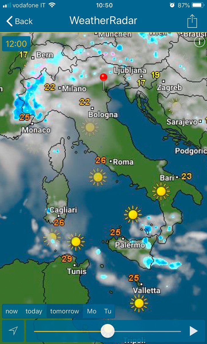
Weather & Radar is one of the most comprehensive free weather apps available. The app delivers current, hourly, and 8-day forecasts from million locations around the world. You have an accurate radar, wind, temperature, alerts, pressure, humidity, rain probability, quantity, and duration.
The weather for your location is instantly displayed with the weather forecast, rain radar, or weather radar. Looking at the weather forecast for the next hours and days, you can instantly see if there will be rain or sunshine. Swipe to the left underneath the radar to see the weather outlook for the coming hours and days.
The weather radar shows you where the sun is shining at the moment, or where it is cloudy. you can also see where it is raining, snowing, or hailing, and where there is currently thunder and lightning. The extensive details provided by the weather radar also include temperature information. Using the search function you can easily find every location and it will automatically be added to your favorites and called up directly. When you tap on the weather radar it will display in a fullscreen view.
4. LIGHT POLLUTION MAP - www.lightpollutionmap.info
Locate dark sites where the sky will not be affected by light pollution

Light Pollution Map allows you to easily locate dark sites where the sky will not be affected by light pollution, allowing the best observance, star gazing, and photography of the night sky.
The map automatically locates you via GPS, and you can find locations with an easy search. Or just look around the map! It's easy to save your favorite dark sites, just push and hold a spot on the map and click the save button. Is the light pollution map overlay too much? You can adjust the opacity to your liking!
The map also features an easy-to-use legend, so you can be sure you are getting the darkest skies possible for star gazing or nighttime photography.
Also included is information on the Moon, such as the Moon's phase, moonrise time, and moonset time! And guess what? That moon information is not only good for the current day, but any day in the future!
Note: The free version is ad-supported, has lower resolution/accuracy, and does not allow you to save your favorite locations. The free version also has limited zoom levels. Upgrade to the pro version in-app for a very small fee to remove ads and unlock all pro features.
You have both the desktop and mobile versions.
MOUNTAIN IDENTIFICATION
5. PEAKVISOR - www.peakvisor.com
The names of all mountains and peaks with a 360° panorama display

Dolomites are my favorite place to shoot, and this app helps me to learn a lot of the names of the peaks step-by-step. PeakVisor is an essential tool for landscape photographers that transforms your iPhone into a mountain-identifying powerhouse using augmented reality (AR) technology. Its ability to work offline and its sophisticated 3D terrain visualization make it invaluable, allowing you to scout potential shooting locations and preview exactly how mountains will appear from different vantage points – perfect for planning golden hour shots. Point your phone at any mountain range, and the app overlays the names and elevations of every peak in view, making it easier to identify compelling compositions and accurately caption your images. Unlike standard mapping apps, PeakVisor's detailed elevation data and prominence information even help predict where clouds might form around peaks, giving photographers an edge in capturing dramatic mountain imagery.
LONG EXPOSURES & CAMERA CONTROL
6. LONG EXPOSURE CALCULATOR
Long Exposure Calculator App makes it easy to shoot long-exposure photography

The Long Exposure Calculator App is the most intuitive neutral density calculator I have used. This app is designed to calculate your image exposures. The idea is you can set the shutter speed you're by a meter reading without any filter on the lens, the ND filter gradation that you are planning to use, and from there, you can calculate what the shutter speed would be if you added the ND filter chosen. It's a very straightforward and very intuitive process. I could use the specific function within the PhotoPills app (below on the right, the interface in PhotoPills), but I prefer the simplicity of the minimalistic controls in this app, which helps me to be a bit faster in the field.
7. CASCABLE - cascable.se
The ultimate smartphone camera remote control app

A Wi-Fi–enabled DSLR or mirrorless camera, paired with a smartphone or tablet, offers several advantages, such as wireless transfer of images, the ability to review shots on a screen larger than the LCD on the camera body, remote shutter control, and other features. All of that requires good software, and too often the manufacturer’s efforts are basic or unreliable.
In my case, Fujifilm has a terrible mobile app to control X-Series cameras, bad Wi-Fi connection performance, problems on synching images between camera and smartphone, and so on. Fujifilm, I love your cameras from the bottom of my heart, but what are you waiting to make the app up to expectations?
DOWNLOAD THE APP: iOS
Cascable (available only for iOS) is the better alternative that adds features many of the camera companies don’t. It’s available for free with a limited but solid set of capabilities. An in-app purchase adds Cascable Pro features.
Even better is the ability to adjust the image settings from the app itself. Tweak shutter speed, aperture, ISO, and exposure compensation using easy-to-use controls. Tap on the screen to set the camera’s focus point. You can display a live histogram to help you avoid over- or under-exposing areas, and a focus peaking option highlights sharp areas in red to aid in getting your focus correct (especially helpful when shooting in the camera’s manual focus mode, although then you need to be near the camera to adjust the lens manually).
IMAGE EDITING
8. VSCO - vsco.co
A responsive image-editing app with a range of useful tone-adjusting presets and photo-sharing community

This is the "go-to app" I use to give a look to the BTS shots captured with my smartphone before I share them on social networks like Instagram or Facebook. The user interface of VSCO is minimal, despite having many tools, with a wide range of gorgeous filters inspired by film look. The main menu is easily accessible as you can swipe to the right, across the screen. This menu allows you to access different features and areas within the app.
VSCO is a brilliant photo editing, sharing, and camera app. You can create quality and subtle edits using this app. Even though VSCO camera doesn’t have different modes like the stock iPhone camera app, you still have access to manual features for better control. Also, you have a platform where you can discover and share photos. The community is brilliant and it is a great place to discover new talents and get inspired.
9. ADOBE LIGHTROOM CC - www.adobe.com
The editing solution for the cloud-based workflow
Lightroom CC is a brand-new application that works across all platforms: desktop, web, and mobile. The new software offers nearly all of the same editing features we're used to but with an entirely new organizational structure reliant upon the cloud. There are so many photo and camera apps, and all work pretty much the same: Take an ordinary smartphone photo and jazz it up with colorful filters.

Lightroom CC takes the darkroom approach to photography. Instead of primarily adding colorful filters to dramatically alter the look of the image, you adjust the things photographers care most about: exposure, shadows, blacks, whites, and color balance, as well as cropping, curve adjustments, split toning, and HSL color panel.
You can get my signature Lightroom presets in my shop!

10. SNAPSEED - www.google.com
The most powerful and intuitive "On the go photo editing app"
Load a photo into Snapseed and it first resembles any me-too one-click filter tool, with you prodding a thumbnail to update the look of your pic. And even if that’s all you download it for, it’s a good choice, because the presets are pretty great. As an editor, Snapseed excels. The range of tools is wide, covering the basics (tune, crop, rotate, heal, and vignette), adding pro-level stuff (curves, DNG support, precision masking, perspective), and enabling you to be properly creative (double exposure, frames, text, and grunge overlays).
Working with tools is wonderfully tactile, with you dragging up and down to select a property and then left or right to adjust an effect’s strength. Best of all, you can visit your edit stack and amend any of your previous steps at any point – everything you do in Snapseed is non-destructive.

GPS TRACKING
11. ALLTRAILS - www.alltrails.com
Countless routes for all sorts of Outdoor activities

AllTrails is a versatile mobile app designed to inspire and guide outdoor enthusiasts, from casual walkers to seasoned hikers. It provides access to a vast database of curated trail maps, complete with detailed information such as difficulty levels, distance, elevation gain, and user reviews.
What sets AllTrails apart is its community-driven approach, allowing users to discover hidden gems through shared experiences, photos, and tips from fellow adventurers. The app also offers offline map functionality, ensuring you stay on track even without cell service—an invaluable feature for exploring remote areas.
With its intuitive interface, GPS tracking, and customizable search options, AllTrails makes planning and navigating outdoor adventures seamless, elevating it above other iPhone apps in the market. Whether you’re hiking, biking, or trail running, AllTrails ensures every journey is safe, efficient, and unforgettable.
It's a very useful app when I have to scout some location in the Dolomites or difficult spots where mid-long hiking is needed.
12. TERRA MAP - www.globalterramaps.com
The best hiking app all around. Find trails, plot routes, and download info for offline use

Why it's on my personal list of the Best Apps for Landscape Photography? Terra Map is the app to satisfy all my hiking needs. You will be able to download the best topo maps and enjoy your new outdoor season. Press the RECORD button, put the phone in your pocket, and record your day. Amazingly clear maps, thanks to the Retina technology usage. Easy to use user interface. You can download maps on the device, to be used later without any internet connection. Topo Maps for the US, Canada, Europe, South America, Asia, Africa, and Oceania (the whole world.).
The app excels in its variety of map layers, combining official topographic maps, OpenStreetMap data, and high-resolution satellite imagery. Photographers can switch between these layers to scout locations, find interesting geological features, and plan shooting positions. The app's 3D terrain visualization helps visualize landscapes before arriving, making it easier to anticipate how light will interact with the terrain.
What sets Terra Map apart is its advanced tracking features and detailed elevation profiles, which help photographers find the optimal paths to reach shooting locations while considering equipment load. The app also includes features like GPS coordinates in various formats, compass bearings, and the ability to create and share custom waypoints—particularly useful when returning to favorite shooting spots or sharing locations with other photographers.
GEO-TAGGING & LOCATION SCOUTING
13. GOOGLE MAPS - maps.google.it
The free app-based GPS navigation with its robust location database and smooth interface

No matter if you’re planning your next photo road trip or you’re scouring the city streets looking for the perfect viewpoint, Google Maps is the most valuable tool to add to your arsenal for finding the perfect photography location.
While planning a trip from home, you have much more time to explore the area in a virtual capacity instead of being out there with boots on the ground. Nothing can compare with actually being there, but the tools available to you are getting better every day, and the ability to nearly frame your shot is a real time saver. Time to turn the volume on your pre-visualization up to 11. It may seem obvious, but for me, Google Maps App is without any doubt one of the Best Apps for Landscape Photography that I couldn't live without it.
Another incredible tool integrated within Google Maps is My Maps which enables users to create custom maps for personal use or sharing. I can add points, lines, and shapes on top of Google Maps. Moreover, I can also have layers and customize the items in each layer with uniform styles and labels for the name or description. There are many different objects you can have as your points, such as the town point, accommodation point, bus point, car park or hut points. You can change the color of anything and change the thickness as well.
14. GOOGLE EARTH - earth.google.com
Fly over a virtual globe and view the Earth through high-resolution graphics and satellite images

Good old Google Earth. If you’ve spent any time near a computer in the last decade or so you’ve probably played with Google Earth, but did you also know you can also use it on your phone?
Google Earth is an incredibly useful tool for scouting out locations from afar. It allows you to easily see buildings, geological features, and other areas that might be of interest to you in planning a shoot. Google Earth uses a very simple interface that you’re probably already familiar with. There’s not much of a learning curve here. Download the app, start getting the land lay, and get ready to shoot away.
I would typically use Photo Pills in conjunction with Google Earth to understand how the light and shadows would look on the mountains, but Google Earth’s representation also leaves something to be desired. Anyway, it's a fantastic tool that I love to use and is a perfect choice that complements the TPE 3D app, and Google Maps is one of the best apps for landscape photography.
FILE-SYNCING AND STORAGE
15. GOOGLE DRIVE - www.google.com/drive/
The simplest and most elegant cloud storage and file-syncing services

Google Drive is my favorite app for images and documents storage and file-syncing. I use it intensively to store images master files, documents about planning and custom google maps, images sharing with photo magazines and web magazines, to backup my smartphone data, and so on. It gives you access to your files from nearly anywhere.
You can install Google Drive on virtually any computer or mobile device. Dozens of apps integrate easily with it, too, making it highly versatile. Google Drive is much more than just a cloud-based storage and syncing service. It also excels at letting you create, edit, store, and collaborate on documents.
The service is truly impressive in just how far it goes to help you create and edit files, whether you're working solo or as part of a team.
Compatibility is rarely an issue with Google Drive: You can upload files, convert them to Google's file format to edit them online—or create new documents, spreadsheets, and slide presentations in the Web interface—and export the finished products to standard file formats, such as .doc, .rtf, .pdf, and so on. With the recently introduced Microsoft Office plugin for Google Drive, you can now use your Google Drive as storage for files you edit with the installed Microsoft Office apps, removing any chance of incompatibility. The first 15GB are free!
EQUIPMENT MANAGEMENT
16. MY GEAR VAULT - www.mygearvault.com
Input, organize, and protect your camera gear

Professional landscape photographers travel a lot and one of the most important things when you are on the road, or before to running a photographic tour, is the gear inventory. Properly managing your gear is a crucial part of the photographer's life. My Gear Vault is an app designed to let you catalog all of your photography equipment in one location. You add data, images, and serial numbers for all your cameras, lenses, and other items via the app so in the event of a theft or loss you have all the insurance-relevant information you need in one place.
With My Gear Vault, you can search through the app’s illustrated database of contemporary digital gear and assign those items to virtual “kits” along with their serial numbers. The app's list of cameras, lenses, and accessories is exhaustive, but you won’t find your precious analog Leica or medium-format cameras there. For older or unique items, My Gear Vault has a manual input option that allows users to photograph their more novel equipment and record serial number information.
"What are your favorite apps for Landscape Photography?"
Let me know and put it in the comments down below.