6 Best Places to Photograph in the Highlands of Iceland

Introduction: My Highlands of Iceland Journey
Back in 2015 I made my first visit into the Icelandic Highlands and was mesmerized by its beauty. An initial mild exploration soon developed into deep love for one of the most beautiful places on earth.
Over the years, I’ve seen it all—waiting for the perfect light on a mountaintop, battling strong winds while slogging through ash fields, and guiding fellow photographers on my workshops through parts of the Highlands that most tourists never get to see. I keep coming back to this place, always discovering something new with every visit.
A good portion of Iceland's Ring Road is itself glamorous; however, the real, raw spirit of the country lies within the rugged interior, some 40,000 square kilometers (about 40 percent of Iceland's total area).
These landscapes continue to inspire me despite countless visits. Together with my beloved Italian Dolomites, Iceland is truly the best playground I could ask for, constantly challenging both me and my photography. It is an endless source of inspiration.
In this guide, I'm sharing a list of six of my favorite photography locations in the Highlands of Iceland, refined through years of experience. These aren't just scenic spots; they're places with endless creative potential for photographers willing to venture beyond the ordinary.
I love every inch of this amazing island, but there's something truly special about the Highlands.
There’s no corner of this island that I don’t love, but the Highlands are the pinnacle of the ultimate photographic experience. This surreal area gives you shots you literally can't capture anywhere else on the planet.

Where are the Icelandic Highlands?
The Icelandic Highlands make up 40% of the nations land area. Represent a rugged expanse shaped by volcanic activity and harsh weather conditions such, as glaciers and extreme climate patterns in Icelands central region between the southern and northern areas of the country, with no urban settlements or developed roads—only unspoiled nature extending through the core of the island.
To reach the Highlands region with its landscapes and geothermal wonders, you can take the F208 road from the south to visit Landmannalaugars vibrant rhyolite mountains and hot springs or head southeast via F35 from the north, along the Kölur route to explore Kerlingarfoll’s geothermal sites and rugged terrain.
The F26 route (known as Sprengisandur), which can be reached from the side of Icelands Vatnajökull National Park, towards Þórsmörkr in the Highlands region, is designed for 4-wheel drive vehicles and serves as a key passage through the Highlands today after being initially constructed during the mid century, for hydroelectric ventures and military objectives.

For ages, the Highlands instilled fear rather than awe in people’s hearts. The early inhabitants of Iceland regarded them as a realm of weather and fantastical tales. Even the name of one of the main routes through the Highlands, Sprengisandur, is derived from the term sprengja, which signifies pushing a horse to its limits. This was necessary for travelers to swiftly traverse the terrain to avoid getting stranded.
Today, the Icelandic Highlands are well known for their scenery, which includes lava fields, active geothermal spots emitting steam, sharp-edged ridges, and deep valleys formed by glaciers.
Despite their isolation, the Highlands have always been part of Iceland’s history. Ancient cairns mark old trails, geothermal pools bubble in the wilderness, and long-abandoned huts tell the stories of travelers who once crossed these lands.
Reaching the Highlands isn’t easy, but that’s part of the experience. The landscape constantly shifts, history feels alive, and nature still holds absolute power.
What is an F road in Iceland?

An F-road in Iceland is a type of mountain road that is specifically designed for off-road vehicles, like 4x4s, due to their rough and often unpaved nature. These roads are the gateway to Iceland’s most remote and rugged areas, including the Highlands.
The "F" in F-road stands for "fjall," which means "mountain" in Icelandic.
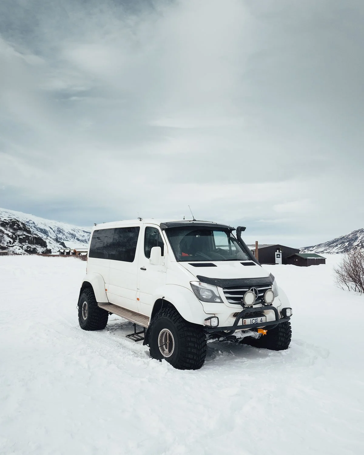
Because they traverse challenging terrain, F-roads can be rough, with deep river crossings, loose gravel, and occasional patches of snow, depending on the season. They're not suitable for regular cars, so if you're planning to explore Iceland’s wilderness, a 4x4 vehicle is essential!
PRO TIP: Tips for Driving on an F-road in Iceland
When driving on an F-road, it’s important to choose the right type of car and understand the unique challenges these roads present. A 4x4 vehicle is a must—this is not the place for a regular rental car.
Many rental agencies offer 4x4 options, and it's wise to book one specifically designed for off-road driving. A 4x4 will give you better control and stability, especially when crossing rivers, navigating uneven terrain, or dealing with rocky paths.

Before you head out, make sure your rental car is fully insured for off-road driving. Standard insurance often doesn't cover damage from F-road conditions, so you may need to opt for additional coverage to ensure you're protected. Also, check the rental contract carefully to confirm that driving on F-roads is allowed—some rental companies restrict driving on these roads, and it’s important to stay within their guidelines to avoid any issues.
Be sure to stay on top of road closures, and if you see a “super Jeep” requirement for a certain road (we’re talking about those big Jeeps with massive tires made to handle tough terrain), take it seriously. Trying to make the drive in a smaller car or city SUV will likely leave you with a hefty repair bill for your rental.

Lastly, always keep in mind that driving on an F-road can be slow and demanding, especially if you're not used to off-road conditions. Take your time, be cautious with river crossings (check water levels before attempting), and be prepared for the possibility of bad weather or unexpected obstacles. Having a fully charged phone and a backup power bank is a good idea in case you find yourself in a remote area.
Also, be sure to fill up your tank before heading out, because there are no full-service gas stations in the highlands.
My Recommended Car Rental in Iceland


If you're planning a self-drive trip to Iceland, I highly recommend Blue Car Rental. Over the past ten years of visiting Iceland, they've consistently been my go-to choice for a reliable rental.
As the largest car rental company in Iceland, they offer great perks like free cancellation, unlimited mileage, 24-hour roadside assistance, and all the essential insurance—SCDW, CDW, TP, and GP—already included in the price.
They're also conveniently located within walking distance of Keflavik Airport, so you can hit the road and start exploring right away. I've always had a smooth experience with them, which is why I’m happy to share this recommendation with you.
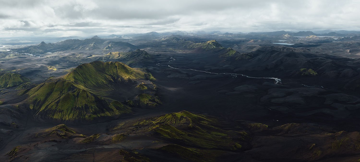
Landmannalaugar: A Land of Colors

When you think of the Highlands of Iceland, Landmannalaugar is likely the first that comes to mind. Not only is it one of the more popular places in Iceland, but the bright colors of the rhyolite mountains make it one of the most colorful. Imagine the pink, orange, and purple peaks that tower over vast lava fields.
Geothermally active, this valley is peppered with hot springs, making it a photographers' paradise (hence its name the ‘People’s Pools’).

An aerial view of Landmannalaugar’s main valley


The area is full of hiking trails that guide you toward beautiful views. One of my favorite hikes is the one to Mount Bláhnúkur, which gets you panoramic views from one of the higher peaks in the area.
Contrary to what many think, this expansive landscape is a fantastic place to use a telephoto lens rather than a wide-angle lens, so don't forget to take one along. It allows you to focus on unique textures, patterns, and distant features, compressing the scene to create compelling compositions.
The focal range I find myself using the most is from 70mm to 300mm. You could go with an even longer lens, but I think in many cases it’s too tight. Of course, it always comes down to personal preference and taste.


Like any of the locations I mentioned in this article, getting there requires a 4x4 vehicle, especially if you are coming from the south, and this includes some river crossing. I would suggest the northern route (F26 or F208), which is comparatively easier and gets you right to this surreal place.
When you do arrive, just take some time to explore and maybe take a relaxing dip in the geothermal hot tubs at the campground. It's an ideal way to cap a day of photography in this beautiful corner of Iceland.
You can watch the two videos below to see some behind-the-scenes footage of the photography workshop I led last year in the Highlands of Iceland.
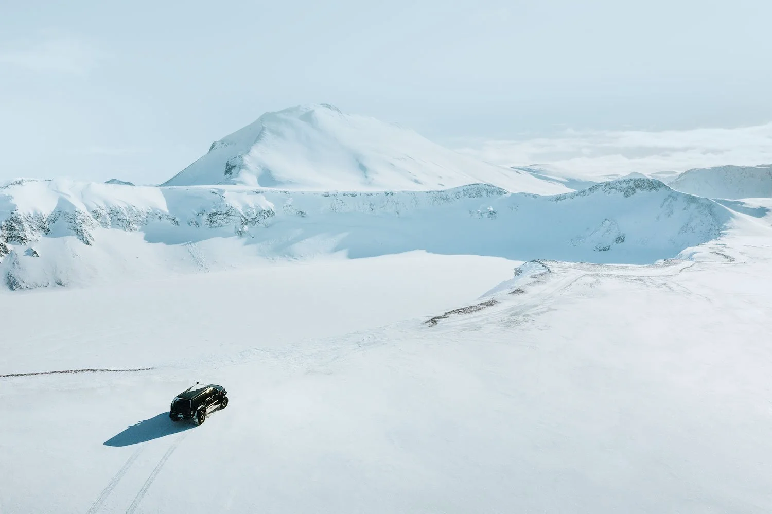
I’ve been lucky enough to visit Landmannalaugar a few times during the winter season, and while I still prefer photographing this region of the Icelandic Highlands in summer, there's something truly transcendent about traversing this region of the Icelandic Highlands when it lies beneath a pristine blanket of snow.
The experience of navigating through approximately three meters of powder in a super jeep creates an almost otherworldly adventure, as the familiar terrain transforms into an expansive canvas of untouched white.

This winter metamorphosis doesn't simply change Landmannalaugar, it elevates the entire photographic experience, revealing new dimensions of this already magnificent landscape through the stark contrast of snow against the occasional glimpses of volcanic elements beneath.
As a huge fan of minimalistic compositions, this is heaven!

Aerial winter view of the Highlands driving towards Landmannalaugar
Aerial winter view of the Hnausapollur crater

The lovely Sigöldufoss waterfall in winter
HOW TO GET TO LANDMANNALAUGAR
Routes: The easiest access is via F26 and F208, both coming from the north.
Difficulty: The roads are moderate, with no river crossings, but expect gravel paths and uneven terrain.
Vehicle: A 4x4 vehicle is required for the journey.
Travel Time: From the Route 26 / Route 32 junction, it takes about 1.5 hours to reach Landmannalaugar.
Kerlingarfjöll: Geothermal Wonderland

Nestled to the southwest of Hofsjökull, Iceland’s third-largest glacier, Kerlingarfjöll is a spectacular mountain range right in the heart of the Highlands. The landscape here is both dramatic and beautiful, with the base of the range sitting at 600-700 meters above sea level, and the tallest peaks soaring up to around 1,500 meters.
These mountains were formed by a series of sub-glacial eruptions during the Ice Age, creating an incredible mix of geothermal features and colorful geological formations.
The area is famous for its rhyolite mountains, calderas, and rare rhyolite mesas—mountains with lava tops. These unique formations add a striking contrast to the landscape, with their vivid hues standing out against the often snowy backdrop.
The geothermal activity here is a highlight: steam vents, bubbling mud pools, and hot springs dot the area, releasing plumes of sulfuric steam into the air. It’s a truly otherworldly scene where colors and textures constantly shift and evolve.


From a photographer's perspective, Kerlingarfjöll offers endless opportunities to capture stunning images, from abstract patterns in the ash-covered snow to close-ups of the fumaroles and wide shots of the steaming valleys.
The interplay of the warm, earthy tones of the mountains with the cool blues and whites of the surrounding snow is especially mesmerizing, giving you rich, layered images. If you're keen on travel and landscape photography, this spot will feel like a dream.


On the way to Kerlingarfjöll, you’ll pass Gýgjarfoss, a waterfall that may not be as famous as some of Iceland’s giants, but it’s worth a quick stop. While it might not boast the same dramatic presence, it has a quiet charm that fits perfectly with the surrounding landscape.
HOW TO GET TO KERLINGARFJÖLL
Route: From Route 35 (the Golden Circle route), continue onto F347, which is a rough gravel road leading into the Kerlingarfjöll area.
Difficulty: Moderate. The road is highland gravel, and parts of it can be rocky and uneven, requiring careful driving.
Vehicle: A 4x4 vehicle is necessary due to the rough terrain and highland roads.
Travel Time: From Gullfoss through Route 35, it takes about 1.5 hours to reach the Kerlingarfjöll parking area, but roads can be slow.
Thórsmörk: The Valley of Thor

Aerial view of Thórsmörk area in winter
Thórsmörk, meaning "Valley of Thor," is one of Iceland’s most breathtaking and remote landscapes, nestled between the glaciers of Eyjafjallajökull, Mýrdalsjökull, and Tindfjallajökull. This rugged wilderness is shaped by the intertwining rivers of Krossá, Þröngá, and Markarfljót, creating a stunning mix of deep valleys, moss-covered mountains, braided rivers, and black volcanic sands.
What makes Thórsmörk truly special are the dramatic views of the glaciers and volcanoes, including the infamous Eyjafjallajökull, which erupted in 2010 and brought air traffic to a standstill.
For hikers and nature lovers, Thórsmörk is nothing short of a paradise. The area offers a variety of trails, from short walks leading to incredible viewpoints to multi-day treks like the famous Laugavegur Trail (someday I’ll do that!).
Every path reveals something different—towering cliffs, hidden canyons, and panoramic views over the highlands. It’s a place where the landscape feels alive, constantly shifting with the light and weather.

Getting to Thórsmörk is part of the adventure. The journey requires navigating the challenging F249 mountain road, which involves multiple river crossings, including the unpredictable Krossá River. I can’t emphasize enough how important it is to have a proper 4x4 vehicle for this drive!
Every year, people underestimate the conditions and end up getting stuck, so it’s crucial to check the weather, water levels, and road conditions before setting off.
Many visitors opt for guided super-jeep tours or take the seasonal highland bus to avoid the risks.
The best time to visit is during the summer, from mid-June to late August, when the trails are accessible, and the landscape is at its most vibrant.
Weather can still be unpredictable, so proper hiking gear is a must. But for those willing to make the effort, Thórsmörk offers one of Iceland’s most immersive and rewarding wilderness experiences—an untamed, ever-changing landscape that feels like it belongs to another world.
HOW TO GET TO THÓRSMÖRK
Route: Take Route 1 (the Ring Road) and turn onto Route 249, which leads to the river crossings. After crossing the Krossá River, follow the gravel roads into the valley of Thórsmörk.
Difficulty: Moderate to challenging. This route involves crossing several rivers, including the Krossá River, which can fluctuate in depth depending on the weather and time of year.
Vehicle: A well-equipped 4x4 vehicle (like a Toyota Land Cruiser) is required to safely navigate the river crossings and rough roads.
Travel Time: From Hella, it takes approximately 1.5 hours to reach Thórsmörk, depending on road conditions and river levels.
Sigöldugljúfur: The Canyon of Multiple Waterfalls

Sigöldugljúfur, known as the "Valley of Tears," stands as one of Iceland's hidden gems nestled in the southern highlands. This remarkable canyon showcases breathtaking natural scenery characterized by dramatic landscapes and numerous cascading waterfalls.
Located east of the famous Landmannalaugar area near the Sigalda hydroelectric power station along the Tungnaá River, this somewhat remote destination requires, of course, a 4x4 vehicle to access via the F208 road.
The canyon stretches approximately 400 meters in length with depths reaching around 40 meters. Its walls consist of layered basaltic rock formations displaying distinctive horizontal striations that reveal the area's volcanic history through successive lava flows.
What truly distinguishes Sigöldugljúfur is the collection of multiple waterfalls that simultaneously cascade down its western wall during peak flow periods, creating the "tears" effect that inspired its nickname.
Drone shot of Sigöldugljúfur canyon in summer during a workshop
At the canyon's base lies a vibrant turquoise-blue lake that strikingly contrasts with the dark basalt rocks and verdant moss covering the canyon walls. This distinctive color derives from glacial silt suspended in water originating from the nearby Vatnajökull glacier, Iceland's largest ice cap.
Sigöldugljúfur has gained popularity among photographers for its otherworldly beauty, particularly during the golden hours when low light illuminates the waterfalls and canyon walls with a warm glow.

Drone shot of Sigöldugljúfur canyon in winter
The canyon's appearance transforms dramatically with the seasons: summer brings peak accessibility with midnight sun and fully flowing waterfalls; autumn displays golden and reddish moss hues with fewer tourists; winter renders the area largely inaccessible as waterfalls freeze into ice formations; and spring sees increased waterfall volume from melting snow as road access gradually improves.
While Sigöldugljúfur remains relatively untouched by mass tourism, visitors are encouraged to practice responsible travel by staying on designated paths, preserving the delicate moss (which takes decades to regrow if damaged).
HOW TO GET TO SIGÖLDUGLJÚFUR
Route: From Route 30, turn onto Route 207 (Sigöldugljúfur Road), a gravel road leading directly to the canyon.
Difficulty: Easy. There is a short walk (about 5-10 minutes) to the canyon viewpoint, which is relatively flat and accessible for most visitors.
Vehicle: A 2WD vehicle can reach the parking area and the trailhead.
Travel Time: From Hella, it takes about 30 minutes to reach Sigöldugljúfur.
Háifoss: Iceland's Iconic Waterfall

Panoramic view of Háifoss captured with multiple wide-angle shots
Háifoss is one of those places in Iceland that never fails to leave me in awe. Standing at around 122 meters (400 feet), it’s one of the tallest waterfalls in the country, and the way it crashes down into the deep canyon below is nothing short of mesmerizing.
Right next to it, Granni—its “neighboring” waterfall—adds even more drama to the scene, creating a powerful duo that feels almost surreal. The whole area is shaped by volcanic activity, with rugged basalt cliffs and vibrant green moss clinging to the canyon walls, making it an absolute dream for photography.
The layers of the falls are nearly 2 million years old, composed of thick lava flows both above and below the waterfall. The most prominent rock is tuff, a type of volcanic rock formed before the last Ice Age. It consists of layers of tephra, which have been compressed and fused together over time.

Every time I visit, I find new ways to capture the mood of this place. The interplay of light and shadow on the canyon walls changes throughout the day, and sunrise or sunset often brings out incredible warm tones in the rock formations.
But there’s more than one way to approach it. You’ll mostly be shooting from the south-southeast, facing north-northwest. Around noon, the sun starts hitting the falls, and the afternoon light is stunning. It's the perfect time to catch rainbows in the mist, making for some truly beautiful shots.

Getting to Háifoss is super easy—there’s a parking lot right next to the waterfall, and it’s only a short walk to get there.
Most visitors stop, take in the breathtaking view of Háifoss and the nearby Granni waterfall from the ridge, snap some photos, and then head back to the car to continue their journey.
However, if you take a moment to explore, you’ll notice a trail that leads down the slope to the gorge at the base of the waterfall. The hike down offers a completely different perspective, and once you're at the bottom, you’ll be in awe of the sheer scale of Háifoss, with its water plunging over 100 meters into the gorge below. After soaking in the view, you can make your way back up to the top.


Telephoto shots from the bottom of Háifoss waterfall
A wide-angle lens is my go-to for showcasing the sheer scale of the scene, but I also love using a telephoto to zoom in on the intricate details—the mist rising from the falls or the way the water carves its way through the landscape.
One of the things I appreciate most about Háifoss is how remote it feels. Unlike some of Iceland’s more popular waterfalls, this one remains relatively quiet, especially outside peak season.
Whether you’re here to photograph it or simply take in the view, it’s one of those places that reminds you just how wild and untouched Iceland can be.
HOW TO GET TO HÁIFOSS
Route: From Route 1 (the Ring Road), take Route 332, which is a gravel road leading to the parking area near Háifoss.
Difficulty: Easy to moderate. There is a short hike (about 10-15 minutes) with a slight incline to reach the viewing area, but it's manageable for most. The trail to get to the bottom of the waterfall (about a 20-minute hike) isn’t too steep, and overall, it’s pretty easy to walk. Just keep in mind that some spots can get wet and slippery, so good shoes and a bit of caution go a long way
Vehicle: A 2WD vehicle is suitable for the main route up to the parking area.
Travel Time: From Hella, it takes about 1 hour to reach the parking area, which is around a 5-minute walk from the waterfall itself.
Langisjór: The Remote Highland Lake

Langisjór is one of Iceland's most stunning and remote highland lakes, located in the country's central highlands near the southwestern edge of Vatnajökull National Park.
The name literally means "Long Sea," which perfectly describes this narrow lake stretching approximately 20 kilometers in length and 2 kilometers at its widest point. Sitting at an elevation of about 670 meters above sea level with a maximum depth of around 75 meters, Langisjór was formed by the dramatic interaction between glacial activity and volcanic processes from the nearby Bárðarbunga volcanic system.
The lake is nestled between the moss-covered Fögrufjöll mountains (aptly named the "Beautiful Mountains") to the east and the Grænifjallgarður volcanic ridge to the west, creating a landscape of remarkable contrasts.
Vibrant turquoise-blue waters stand out against dark volcanic sand and lush green moss, presenting a photographer's paradise, particularly during the short summer season from July to early September when temperatures typically range from 5-15°C.
During this brief window, the area experiences almost 24 hours of daylight, while harsh winters bring freezing temperatures, limited daylight, and make the region largely inaccessible.

Geologically, the area showcases Iceland's dynamic processes with evidence of subglacial volcanic eruptions, expansive lava fields, hyaloclastite ridges formed when lava erupted beneath ice age glaciers, pumice deposits from explosive eruptions, and visible effects of ongoing glacial retreat.
The most impressive landmarks include Sveinstindur mountain (1,090m) with its spectacular panoramic views, the distinctively green moss-covered Fögrufjöll mountains, dramatic volcanic formations along Grænifjallgarður ridge, and several small islands within the lake.


Langisjór's remote location makes it one of Iceland's less-visited regions, requiring a sturdy 4x4 vehicle with high clearance to navigate the F-roads that are only open during summer months.
The area offers only basic campsites with no permanent services, attracting adventure travelers, photographers, and those seeking solitude in nature. Photographically speaking the landscapes here are literally mind-boggling!

HOW TO GET TO LANGISJÓR
Route: From Route 26, take Route 208, a highland gravel road that runs through a remote area and leads directly to Langisjór Lake.
Difficulty: Moderate to challenging. The roads are rough, and conditions in the highlands can change quickly. Before adventuring into the region, I always recommend checking the weather and road conditions.
Vehicle: A 4x4 vehicle with high clearance is essential to handle the rugged highland terrain.
Travel Time: From Route 26, it takes about 2 hours to reach Langisjór Lake, but travel time can vary depending on road conditions.
Join Me on a Photo Tour in Iceland

If you're a passionate photographer and want to explore these locations, along with many others, I’d love to be your photography guide and help you fast-track your growth as a photographer. I'd love to have you join me on this unique photography adventure. Click the button below to learn more about the trip and sign up!